- ▾ Other ShakeOuts ▾
- Alaska
- American Samoa
- Arizona
- British Columbia
- California
- Central U.S. (AL AR IA IL IN KS KY LA MO MS NE OH OK TN)
- CNMI
- Colorado
- Guam
- Hawaii
- Idaho
- Japan
- Montana
- Nevada
- New Mexico
- New Zealand
- NorthEast U.S. (CT MA ME NH NJ NY PA RI VT)
- Oregon
- Puerto Rico
- Quebec & Eastern Ontario
- SouthEast U.S. (DC DE FL GA MD NC SC VA WV)
- Texas
- Upper MidWest U.S. (MI MN ND SD WI)
- U.S. Virgin Islands
- Utah
- Washington State
- Wyoming
- Yukon
- Other Countries

Inland Southern California Earthquake Hazards

Inland Southern California is graced with spectacular scenery and diverse communities. Those lucky enough to live among the mountains, valleys, and deserts know how breathtaking the area can be. This region has been fashioned by tremendous geologic forces and, like all of California, is earthquake country. Understanding the risks and preparing to survive and recover can help keep your family safe.
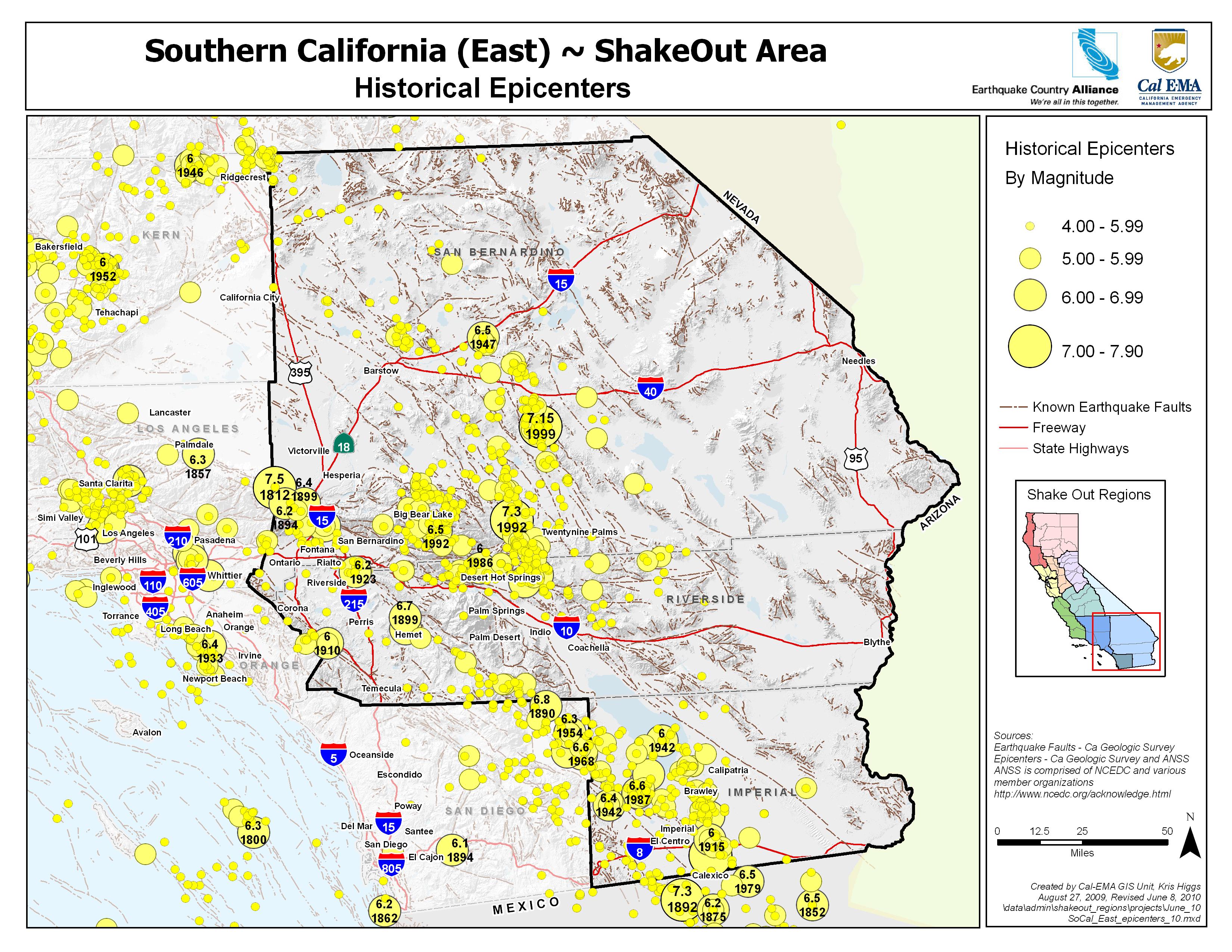
Most people in Inland Southern California live less than 10 miles from a fault that can have a damaging earthquake and a large part of the population lives along the most potentially damaging fault of all - the infamous San Andreas. It slices through the region, and has the potential to produce a devastating earthquake. Nearby faults such as the San Jacinto fault create smaller, yet more frequent earthquakes.
Life After a Big Quake
These earthquakes will disrupt services like electricity, water and sewer, and may limit access in and out of the region. Fire and police departments will be dealing with the most serious situations and may be unable to respond quickly to issues in your community. Government assistance may not be available or not enough to replace your damaged belongings or repair your home. Good news: Preparing now will give you confidence that you and your family will stay safe where the earth shakes.
Participants
people are currently registered to participate in this year's Great California ShakeOut.
are from
the Inland Southern California area.
Number of Inland Southern California participants in each category
View names of participants:
Learn More
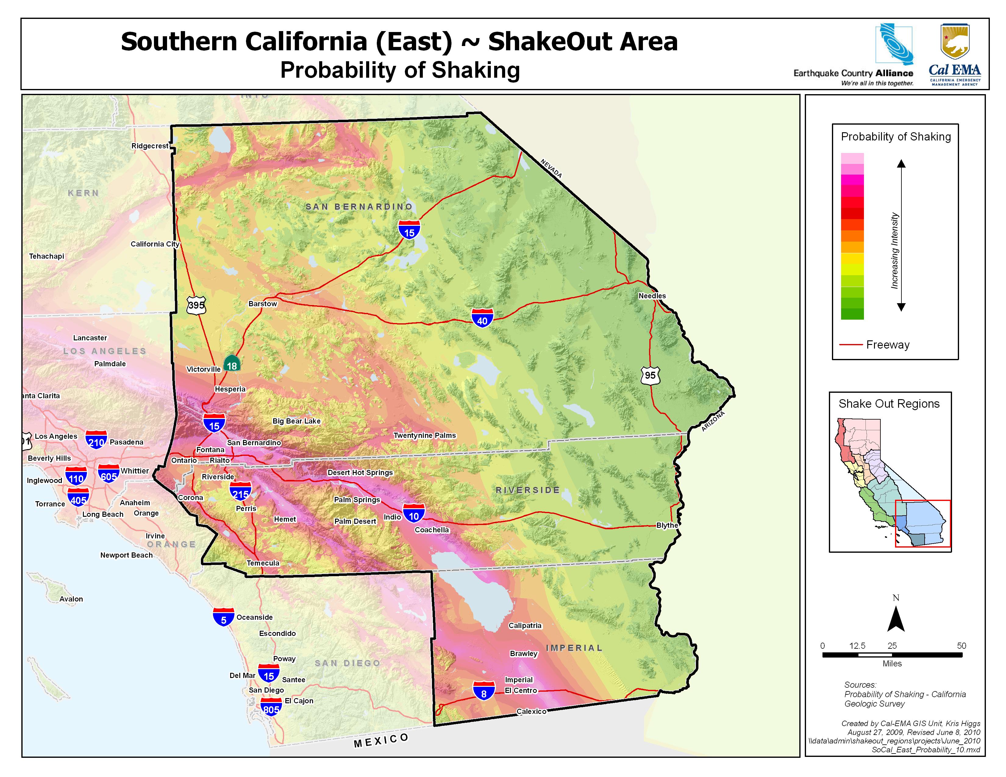
The Inland Southern California area is highly susceptible to earthquakes and earthquake related effects. The two most active faults in California run through the most populated areas of the region and the likelihood of a very large earthquake in this area is higher than almost any other place in the state.
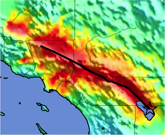
Designed for the original ShakeOut in 2008, the ShakeOut Scenario portrays a magnitude 7.8 earthquake along the southern San Andreas fault. Much more can still be learned in preparing for such a large earthquake! The Scenario is a product of the United States Geological Survey, Multi-Hazard Demonstration Project, led by Dr. Lucy Jones.
The driving force of earthquakes in California is movement along the San Andreas Fault and the many associated faults within the San Andreas Fault System that form the tectonic boundary between the Pacific and North American tectonic plates. The San Andreas Fault is the most active in the contiguous United States however the Fault has not ruptured in this southern section for over 300 years. The ShakeOut Scenario describes what may happen when a large earthquake on the fault finally happens again (which could be today).
Yet while the San Andreas Fault is the longest and fastest moving fault in the state it is by no means the only one to be concerned with. Many other faults are found directly beneath our cities in some of the most densely populated areas. The San Jacinto Fault is the second fastest moving fault in California, and in combination with the San Andreas accommodates most of the relative movement along the plates in southern California. Also, the Eastern California Shear Zone in the Western portion of the Mojave Desert is an area of multiple faults that has produced large earthquakes, including the magnitude 7.3 Landers earthquake in 1992, and the magnitude 7.1 Hector Mine earthquake in 1999. Because of their location in a less populated part of San Bernardino county, they caused relatively little damage.
People of in the Inland Southern California Area have special concerns that might not be relative to other areas. Many people cross the San Andreas fault when traveling between home and work. During a major earthquake freeways may be broken and take days or weeks to repair, making it difficult or impossible to return home.
In addition to damage caused directly by groundshaking and related groundfailure, other hazards such as fires can easily start during and shortly after an earthquake. Fires may spread quickly in densely-built neighborhoods, enabling them to sustain for long periods, spread over large areas and, due to broken water pipes and the number of ignitions, simply overwhelm the abilities of firefighters to control them. On the other hand, earthquakes occurring during periods of heavy rain can produce destructive and life threatening slurry-like debris flows that originate on the steep slopes and gullies of the many rugged mountain areas and can flow into adjacent communities.
Large earthquakes anywhere in the Inland Southern California area can affect you, even if the shaking is not strongly felt where you happen to be. Consider what might happen to the nation's economy if the freeways and railroads passing through the Cajon and Banning Passes were put out of commission, and the normal flow of goods were to be disrupted. What if a freeway overpass along your commute were to be heavily damaged or destroyed? How would you find drinking water if subsurface supply pipes are broken? We all must consider these and other plausible scenarios that can happen at any time and take measures that would minimize their impacts.
If you live in the Inland Southern California area, it is likely that a damaging earthquake will occur and affect you during your lifetime. You decide your fate. You decide your future. The steps you take now can mean the difference between your success or failure after the next big quake. Start now!
Additional earthquake hazard information:
Fault maps, historic earthquakes, how the ground is expected to shake, and much more
California Geological Survey (CGS)
Forecast of California Earthquakes
Southern California Earthquake Center, USGS, and CGS
Fault and earthquake maps, shaking hazard maps, liqufaction maps, and other information
United States Geological Survey, Northern California
Earthquake Shaking Potential Map of California (Dec. 2008)
California Geological Survey (CGS)
Earthquake, Tsunami & Volcano Programs
California Governor's Office of Emergency Services
Maps of recent earthquakes, ShakeMaps for larger earthquakes, email notification, and more
California Integrated Seismic Network
Where do I go for more information and who do I turn to for help in the Inland Southern California region?
In San Bernardino County:
www.sbcfire.org
San Bernardino County Fire Office of Emergency Services: www.sbcfire.org/oes/about.aspx
San Bernardino County 2-1-1 (United Way) ieuw.org/211-san-bernardino
San Bernardino County Disaster Recovery Assistance www.sbcounty.gov/main/evocrecovery.asp
Live disaster information for San Bernardino County www.sbcounty.gov/main/evocdata.asp
In Riverside County:
countyofriverside.us/Residents/Emergencies.aspx
rivcoemd.org/About-Us
rivcoemd.org
www.countyofriverside.us/emergencies
In Imperial County:
www.icphd.org
www.icso.org
Imperial County Office of Emergency Services: (760) 482-2400
After-Hours Emergency Contact Number: (760) 355-1191