- ▾ Other ShakeOuts ▾
- Alaska
- American Samoa
- Arizona
- British Columbia
- California
- Central U.S. (AL AR IA IL IN KS KY LA MO MS NE OH OK TN)
- CNMI
- Colorado
- Guam
- Hawaii
- Idaho
- Japan
- Montana
- National
- Nevada
- New Mexico
- New Zealand
- NorthEast U.S. (CT MA ME NH NJ NY PA RI VT)
- Oregon
- Puerto Rico
- Quebec & Eastern Ontario
- SouthEast U.S. (DC DE FL GA MD NC SC VA WV)
- Texas
- Upper MidWest U.S. (MI MN ND SD WI)
- U.S. Virgin Islands
- Utah
- Washington State
- Wyoming
- Yukon
- Other Countries
Central Valley (South) Earthquake Hazards

With stunning landscapes as its backdrop and agriculture at the core of its economy, those who live in the southern Central Valley know how timeless the area can be. But like all of California, the southern Central Valley is earthquake country. Shaking can begin suddenly but have lasting impacts. Understanding the risks and preparing to survive and recover can help keep your family safe.
The Central Valley is ringed by faults – the San Andreas fault, California’s largest, on the west, the Garlock fault to the south, and the faults of the Sierra Nevada to the east. The San Andreas fault will create the biggest earthquakes – as big as magnitude 8 – that will disrupt the whole region. But an earthquake near you can be more damaging to your house than magnitude 8 farther away.
Life After a Big Quake
These earthquakes will disrupt services like electricity, water and sewer, and may limit access in and out of the region. Fire and police departments will be dealing with the most serious situations and may be unable to respond quickly to issues in your community. Government assistance may not be available or not enough to replace your damaged belongings or repair your home. Good news: Preparing now will give you confidence that you and your family will stay safe where the earth shakes.
Participants
people are currently registered to participate in this year's Great California ShakeOut.
are from
the Central Valley (South) area.
Number of Central Valley (South) participants in each category
View names of participants:
learn more
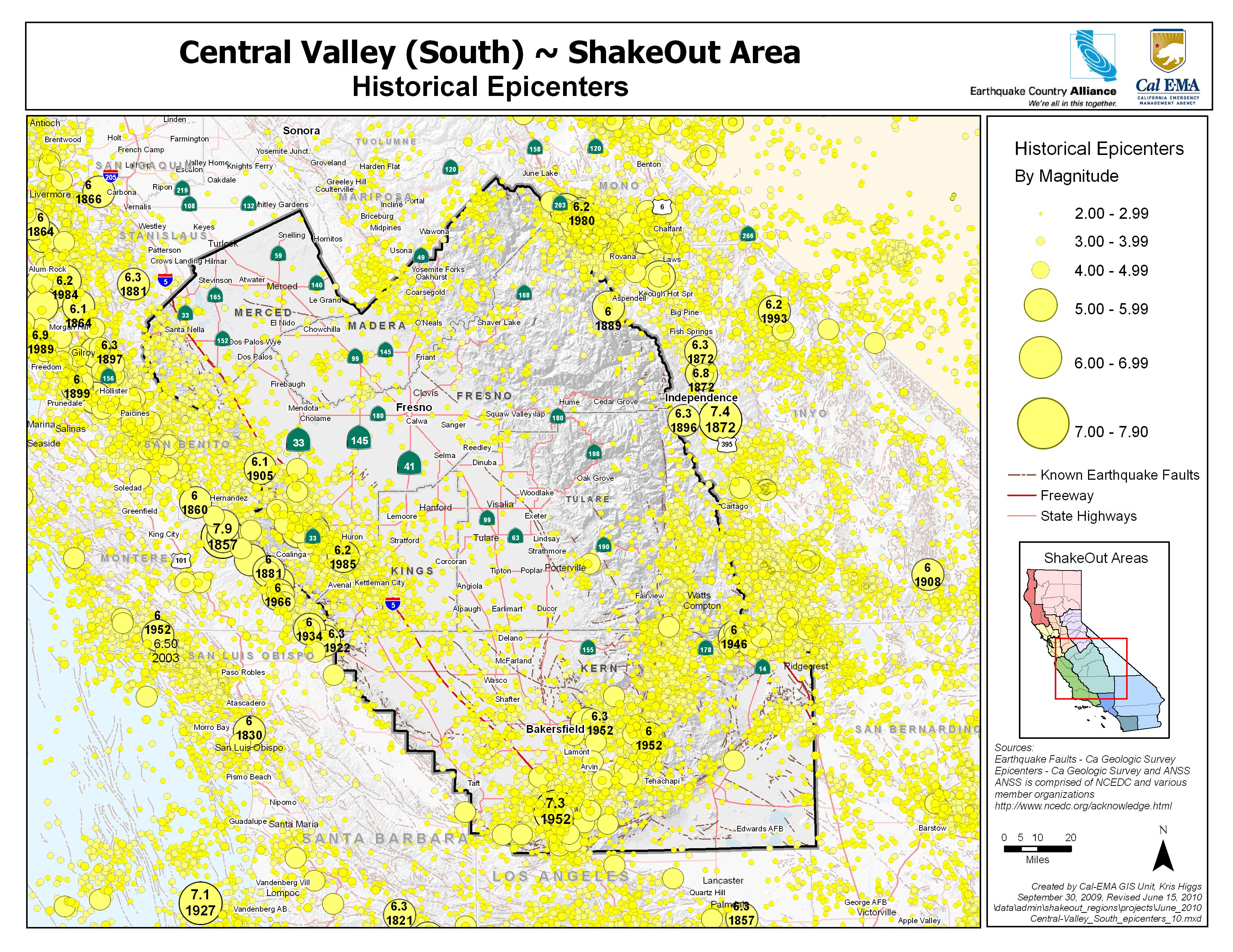
Long-time residents of the Central Valley (South) ShakeOut Area are undoubtedly familiar with the occasional “roll” of a distant earthquake centered somewhere along on the San Andreas Fault to the west. However, few know that there are actually damaging earthquake-producing faults underlying the valley itself, particularly along its western margin. Here, numerous faults make up what is referred to as the San Joaquin fault zone. These faults are generally not well defined because they are deeply buried by valley sediments. Included in this group is the Nunez Fault that in 1983 produced a strong (about M6.5) earthquake centered near Coalinga and causing significant damage.
Because we cannot yet define their actual geometries and continuity, it is impossible to calculate what ground motions are likely to be produced by ruptures along these faults. However, we do know that the shaking can be significantly damaging as indicated by the 1983 Coalinga earthquake and the Vacaville-Winters earthquake that struck in western Sacramento Valley in 1892.
The underlying fact is that residents of the Central Valley South area are not immune to damaging earthquakes and, therefore, should take preventative measures to prevent injuries to themselves and loved ones, as well as to minimize damage to their homes, businesses, and communities.
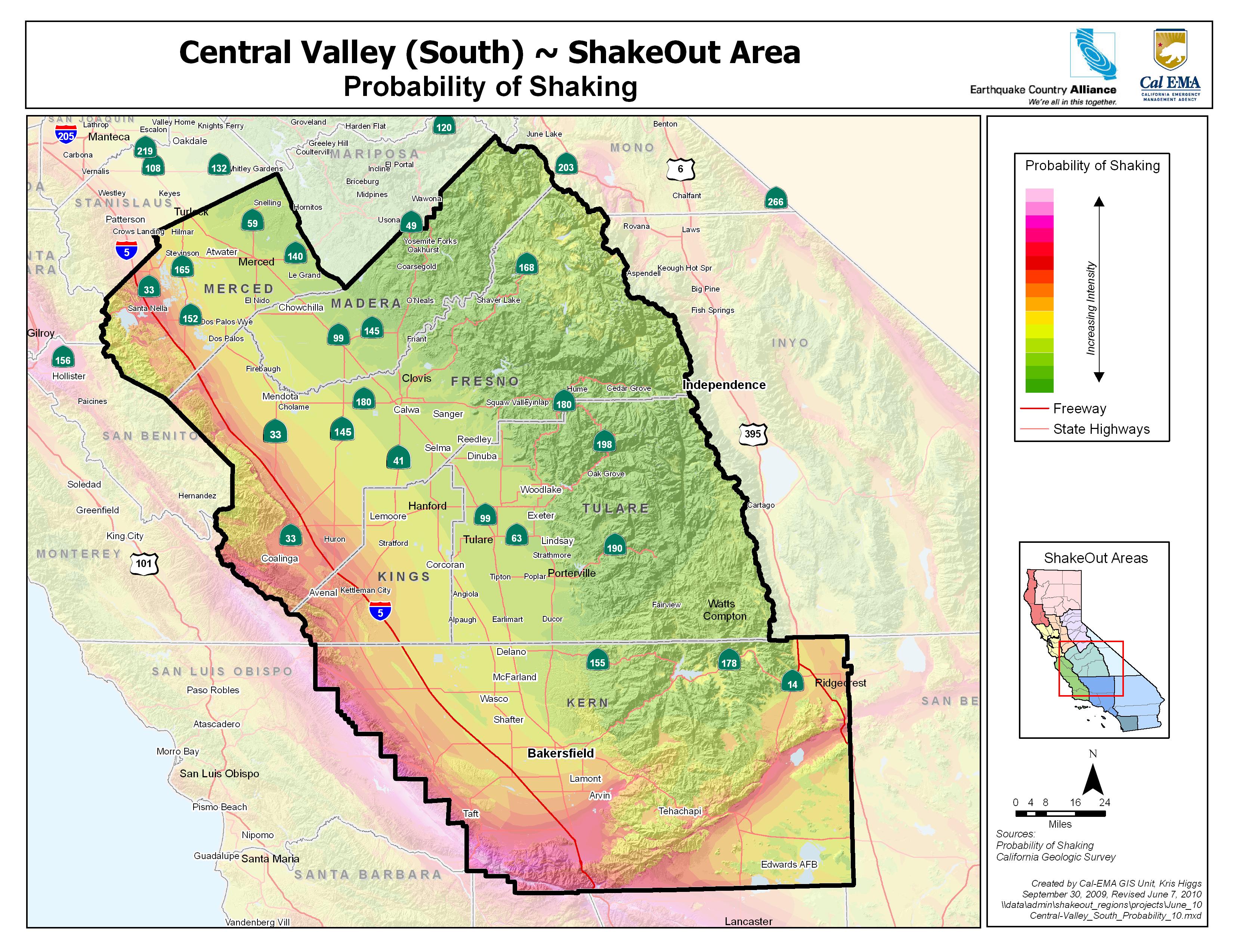
Earthquake Shaking Potential,
Central Valley (South) Area
Central Valley (South) Area
Epicenters and Faults
The following links provide local and statewide earthquake hazard information:
MyHazards
California Governors Office of Emergency Services
Use this website to discover the hazards that exist in your area and learn how to reduce YOUR risk!
Fault maps, historic earthquakes, how the ground is expected to shake, and much more
California Geological Survey (CGS)
Forecast of California Earthquakes
Southern California Earthquake Center, USGS, and CGS
Maps of recent earthquakes, ShakeMaps for larger earthquakes, email notification, and more
California Integrated Seismic Network
Earthquake Shaking Potential Map of California (Dec. 2008)
California Geological Survey (CGS)
Earthquake, Tsunami & Volcano Programs
California Governor's Office of Emergency Services
Fault and earthquake maps, shaking hazard maps, liquefaction maps, and other information
United States Geological Survey, Northern California
Where do I go for more information and who do I turn to for help in the Central Valley South Region?
In Fresno County: www.co.fresno.ca.us/DivisionPage.aspx?id=1568
In Kern County: www.co.kern.ca.us/emergency
In Kings County: www.kingcounty.gov/safety/prepare
In Madera County: www.madera-county.com/index.php/office-of-emergency-services
In Mariposa County: Call Mariposa County Public Health (209) 966-3689 or visit www.mariposacounty.org
In Merced County: www.co.merced.ca.us
In Tulare County: www.Tularecounty.ca.gov or http://tularecounty.ca.gov/oes