- ▾ Other ShakeOuts ▾
- Alaska
- American Samoa
- Arizona
- British Columbia
- California
- Central U.S. (AL AR IA IL IN KS KY LA MO MS NE OH OK TN)
- CNMI
- Colorado
- Guam
- Hawaii
- Idaho
- Japan
- Montana
- Nevada
- New Mexico
- New Zealand
- NorthEast U.S. (CT MA ME NH NJ NY PA RI VT)
- Oregon
- Puerto Rico
- Quebec & Eastern Ontario
- SouthEast U.S. (DC DE FL GA MD NC SC VA WV)
- Texas
- Upper MidWest U.S. (MI MN ND SD WI)
- U.S. Virgin Islands
- Utah
- Washington State
- Wyoming
- Yukon
- Other Countries

Inyo-Mono Earthquake Hazards

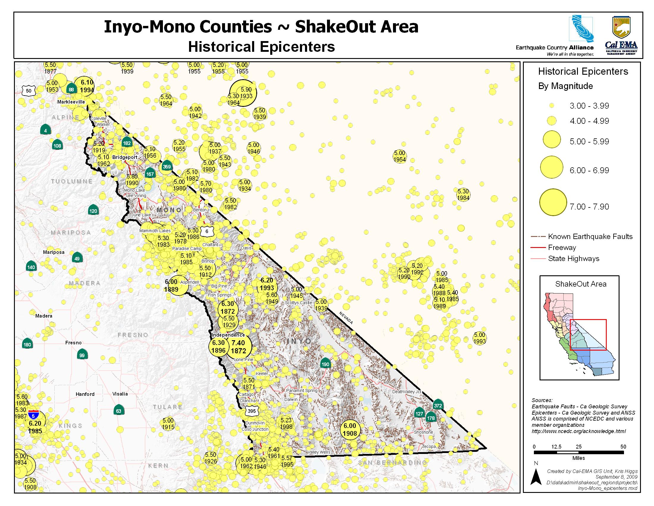
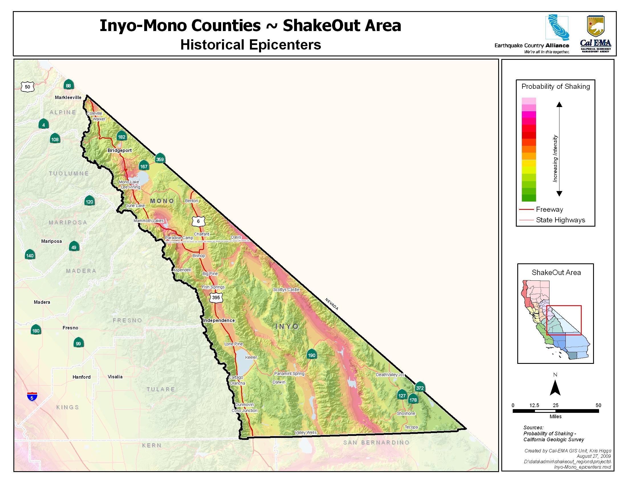
Inyo and Mono counties lie astride the eastern side of the California’s Sierra Nevada range and are home to spectacular scenery that is world famous. Those lucky enough to live among the mountains and valleys know how breathtaking the area can be. But this region has been fashioned by tremendous geologic forces, witnessed by the incredible steep slope from Mt. Whitney to the Owens Valley in Inyo County. Inyo-Mono, like all of California, is earthquake country. Understanding the risks and preparing to survive and recover can help keep your family safe.
Residents of the eastern Sierra counties of Mono and Inyo live less than 15 miles from a fault that can have a damaging earthquake. Active faults along the front of the range, as well as within the basins and have produced earthquakes that have had a human toll in historic times.
Life After a Big Quake
These earthquakes will disrupt services like electricity, water and sewer, and may limit access in and out of the region. Fire and police departments will be dealing with the most serious situations and may be unable to respond quickly to issues in your community. Government assistance may not be available or not enough to replace your damaged belongings or repair your home. Good news: Preparing now will give you confidence that you and your family will stay safe where the earth shakes.
Participants
people are currently registered to participate in this year's Great California ShakeOut.
are from
the Inyo-Mono area.
Number of Inyo-Mono participants in each category
View names of participants:
learn more
A strong earthquake swarm in May of 1980, which included four magnitude 6 earthquakes near the southern margin of the caldera and increased uplift and extension of the Long Valley Caldera, marked the onset of the latest a period of activity in the caldera. This activity continues today and includes recurring earthquake swarms and continued dome-shaped uplift of the central section of the caldera accompanied by changes in thermal springs and gas emissions. Long Valley - United States Geological Survey.
MyHazards
California Governors Office of Emergency Services
Use this website to discover the hazards that exist in your area and learn how to reduce YOUR risk!
Fault maps, historic earthquakes, how the ground is expected to shake, and much more
California Geological Survey (CGS)
Forecast of California Earthquakes
Southern California Earthquake Center, USGS, and CGS
Earthquake Shaking Potential Map of California (Dec. 2008)
California Geological Survey (CGS)
Maps of recent earthquakes, ShakeMaps for larger earthquakes, email notification, and more
California Integrated Seismic Network
Earthquake, Tsunami & Volcano Programs
California Governor's Office of Emergency Services
Where do I go for more information and who do I turn to for help in Mono and Inyo Counties?
Q. I need to find a shelter. Where are they?
In Inyo County: Call (760) 878-0383, visit www.inyocounty.us/so, and tune to your local radio stations:
KSRW - 92.5 FM & 96.5 FM
KIBS - 100.7
KBOV – 1230 AM
KMMT – 102.3 FM
In Mono County:
Call (760) 932-7549 or go to www.redcross.org
Q. This booklet has been helpful, but I want even more information. Where do I go?
Mono County: Visit www.monosheriff.org
Inyo County: Visit the website of the Office of Emergency Services www.inyocounty.us/OES/emergency_planning_and_disaster_supplies.htm or call: (760) 878-0292
After-Hours Emergency Contact Number: (760) 878-0383